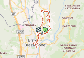
Trail Walking Brixen - Bressanone - Brixen - Archeopfad - Photo
© OpenStreetMap contributors
Length
Length
7.5 km
Max alt
Max alt
845 m
Uphill gradient
Uphill gradient
287 m
Km-Effort
Km-Effort  
11.4 km
Min alt
Min alt
561 m
Downhill gradient
Downhill gradient
289 m
Boucle
Boucle
Yes
Creation date :
2025-07-24 08:44:14.579
Updated on :
2025-07-30 16:03:30.375

(0 Reviews)

Walking
Walking
3h55
Difficulty : Easy

Scan this QR Code to open this trail in the SityTrail application

FREE GPS app for hiking

Logo SityTrail SityTrail

IGN / Geographical institutes

Download SityTrail from the App Store Download SityTrail from Google Play

Logo SityTrail SityTrail Plus

The world is yours!

Download SityTrail from the App Store Download SityTrail from Google Play Download SityTrail on Huawei AppGallery

About

Trail Walking of 7.5 km to be discovered at Trentino-Alto Adige/Südtirol, South Tyrol, Brixen - Bressanone. This trail is proposed by VacheKiri67.

Description

Faite le 24/07/2025 avec nos amis Francine et Christian. D'après "Wandern in Südtirol - 66 : Auf dem Archeopfad zwischen Brixen und Elvas". Durée indiquée pour le circuit : 1h45. Avec petit tour dans Brixen.

Elevation profile

Photos

39 photos in total. Please click on a photo to see them all in the gallery.

Positioning

Country:
Italy
Region :
Trentino-Alto Adige/Südtirol
Department/Province :
South Tyrol
Municipality :
Brixen - Bressanone
Location:
Unknown
Start:(UTM)
703518 ; 5177528 (32T) N.


Close
My subscriptions